The location map beta is released.
The everviz location map allows anyone in the newsroom to create news maps in seconds. Drop markers and pins to show viewers where news is breaking.
Add map themes, 3D buildings, a mini map and more. This moves map creation from designers to journalists.
Map it out
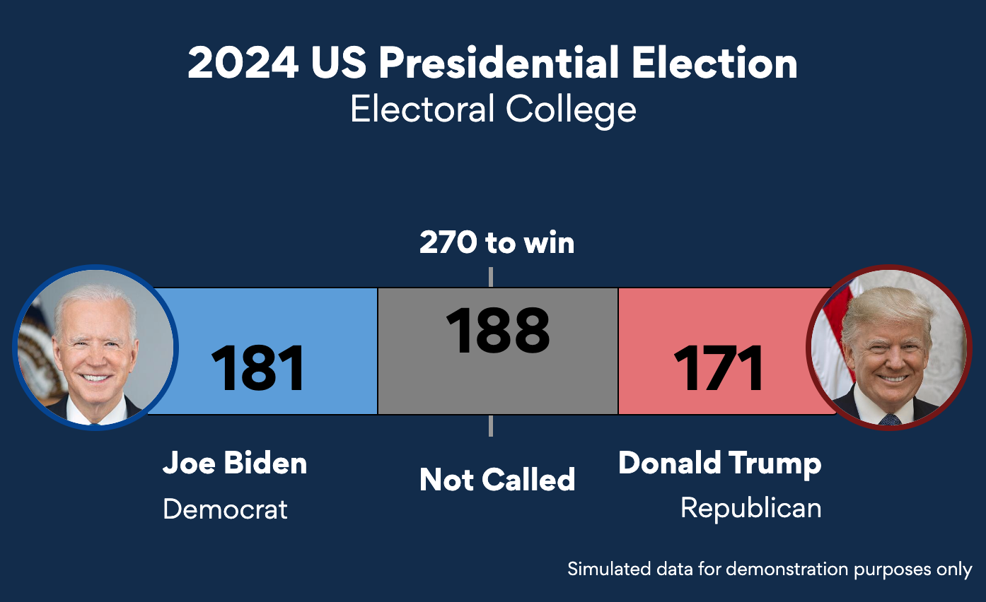
Say a journalist gets word of a car accident over the police wire.
First responders are rushing to the site, an intersection in a densely populated part of downtown.
The journalist writes a quick story and publishes it online. They quickly create a location map to accompany the article.
Maps on all platforms
The above map can be added to a video package, live stream, social media post and more.
Maps in a video package
Media outlets use maps in their video packages on a daily basis.
Export a video of the map complete with animations with alpha. Drop it a timeline in a video editor overtop of footage, adding an extra crucial layer of information.
Maps in a live stream
everviz’s integration with Viz Flowics enables inserting maps in live broadcasts.
Viz Flowics has an HTML-based playout engine, everviz maps are HTML-based. It’s a match made in heaven. Simply copy the Viz Flowics URL from everviz, paste it into Viz Flowics, click take to air and bob’s your uncle, the map is included in your live stream..

Supporting a online news article
everviz’s heritage is providing interactive and accessible online charts and maps.
Users can interact with a map in an online article by zooming, clicking and more, while a presenter interacts with the same map on a touch screen live in studio.
Map themes included
Your brand colors, fonts and logo can be added to everviz maps using the everviz theming concept.
The individual map elements can also be customized. Media outlets have a slew of preferred map icons and markers. These can be easily imported into everviz.

Animations and zooming
Providing context is key to telling a good story.
This is where map zooming comes into play. Our dev team is hard at work building map animations. This enables zooming into a region or city by setting keyframes. Defining pause length between animation points will also be added.
We want to hear from you!
Interested in testing the location map? Email [email protected] for access.